Welcome
The West Gippsland region is one of the most diverse and complex natural resource management regions in Australia. It extends from coastal San Remo in the west to Lakes Entrance in the east and north to Mount Howitt, high in the Victorian Alps. It supports intensive agriculture and forestry industries, as well as tourism which is equally reliant on our natural resources. The region has extensive brown coal resources associated with power generation, along with other extractive industries. Major water resources are relied upon for urban and rural communities (including a large part of Melbourne’s water supply), the environment and industry. It is interesting to note that 46% of the region is public land, and 54% is private land.
With population growth occurring across much of the region, we must be mindful of the explicit value of these natural resources including iconic features such as Wilsons Promontory, the Gippsland Lakes and associated wetlands.
The Regional Catchment Strategy (RCS), is West Gippsland’s overarching strategic document for managing land, water, and biodiversity in the region. This is the fourth RCS and has built on previous versions and their achievements. The RCS outlines the management challenges and together with regional stakeholders, the agreed directions for natural resource management across West Gippsland. The RCS is a key document for the whole region and agency, stakeholder and community involvement in the renewal process has been vital to ensure that this RCS truly reflects local and regional priorities.
Input has also been sought from the community on views and aspirations for managing land, water and biodiversity in their local areas. A constant feature of our approach has been the engagement of energetic local people and organisations to take action that helps ensure future generations and the environment benefit from the region’s many natural resources.
The RCS includes information at the regional scale for six management themes: water, land, biodiversity, coast and marine, community and traditional owners. It also includes a focus on eight ‘local areas’ that cover the whole region. The purpose of local area content in the RCS is to reflect the local communities’ priorities and interests and to show how agencies and communities work together to deliver integrated catchment management at the local level.
The RCS will guide the activities of government agencies and partner organisations from 2021 to 2027. The RCS doesn’t include the finer details and implementation priorities; however, these are outlined in supporting management plans and strategies, such as the West Gippsland Waterway Strategy, West Gippsland Floodplain Management Plan, Ramsar Management Plans and Gunaikurnai Whole of Country Plan.
A highlight for this fourth RCS, is the involvement of our Traditional Owners in its development from the beginning. This RCS is underpinned by the aspirations of our Traditional Owners in the management of natural resources across West Gippsland. We recognise and respect their unique cultural heritage, beliefs and intrinsic connection to Country, and we look forward to working closely with them in the implementation of this strategy.
We also look forward to continuing to work with all of our regional stakeholders throughout the implementation of this RCS for the enhancement, resilience and management of our region’s natural resources.
Mikaela Power
Chair
West Gippsland Catchment Management Authority
Our Region
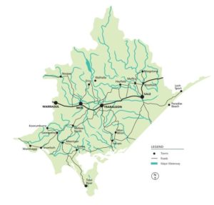
The West Gippsland Catchment Management Authority (CMA) region extends across west, south and central Gippsland. From Warragul and San Remo in the west to the Gippsland Lakes in the east, and from the Great Dividing Range in the north to Wilsons Promontory in the south. The region also extends three nautical miles into marine waters, which marks the State of Victoria’s jurisdictional limit.
The region covers an area of 19,639 square kilometres (including marine environment) and accounts for almost eight percent of Victoria’s total land area, with a population more than 200,000 people. Unlike regions with a single major city, the West Gippsland population is dispersed between several regional centres in the vicinity of the Princes, South Gippsland, Strzelecki, Hyland and Bass highways. The region includes parts of seven municipalities: all of Latrobe City; substantial parts of Wellington, Baw Baw and South Gippsland shires; a well-populated portion of Bass Coast shire; and sparsely populated areas of Mansfield and East Gippsland shires.
The West Gippsland CMA region is expected to experience population growth of approximately 20% by 2036, particularly the western part of the region with its proximity to the peri urban fringe of Melbourne. However, the population is also expected to continue to age and decline in most rural areas of the catchment. This is being accompanied by a continuing shift of services into the larger regional centres.
The Gunaikurnai, Bunurong and the Wurundjeri peoples are the traditional custodians of the country covered by this region. There are also some parts of the region where there are multiple interested Traditional Owner groups including areas where there has not been a determination.
Gunaikurnai country extends from the coast near Wilsons Promontory, up to Mount Baw Baw and across a large part of East Gippsland. Clans of the Gunaikurnai include the Bratauolung in South Gippsland, the Brabiralung and Braiakaulung in Central Gippsland, and the Tatungalung around the Gippsland Lakes.
Bunurong country extends to parts of the south and west of the region. Parts of the north-west of the region are Wurundjeri country.
West Gippsland is rich in natural resources and supplies water, electricity, gas, oil, saw logs, pulpwood, agricultural products, and tourism opportunities to people both within and beyond the region’s boundaries. The estimated Gross Regional Product for the region is more than $2.5 billion and Total Regional Output, including production of intermediate goods and services, is estimated at over $9 billion.
Major sectors as defined by the Australian Bureau of Statistics, include manufacturing, electricity, gas, water, agriculture, forestry, fishing, property and business services. The agriculture, forestry and fishing sectors and the electricity, gas and water sectors are important employers in our region.
Dairying accounts for half of the agriculture production and beef another quarter. Wool, lamb, horticultural produce, and a variety of other enterprises make up the remainder. The region provides over 90% of the state’s electricity and gas, 27% of Melbourne’s water, and has two thirds of Australia’s total oil production. Private plantation, public forestry and tourism are also significant industries.
A major long-term industry transition is also underway in the Latrobe Valley, with the closure of the Hazelwood mine and power plant, and the potential closure of the Yallourn coal-fired power station in 2028 and Loy Yang in 2048. This transition is expected to have a large impact on the local economy affecting local jobs and businesses.
The region at a glance
| Total land area | 17,685km |
| Population | 200,000 approx. |
| Tenure | 46% public land and 54% private land |
| River basins | Latrobe, Thomson and South Gippsland |
| Traditional custodians | Gunaikurnai, Bunurong and Wurundjeri people |
| Largest contributors to the regional economy | Construction, mining, manufacturing, forestry, agriculture, fishing, food-related and utilities sectors |
| Largest employment sectors | Healthcare, social assistance and retail trade2 |
| Wetlands of International Importance | Gippsland Lakes and Corner Inlet Ramsar sites |
| The region provides | 23% of Australia’s milk production, most of Victoria’s electricity and gas (offshore) and about 60% of Melbourne’s water. |


