Introduction
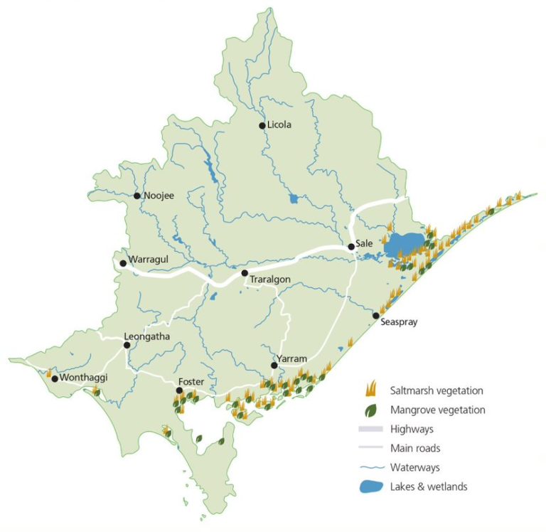
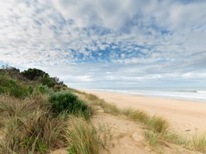
West Gippsland’s marine and coastal environment extends from San Remo in the west to opposite Lakes Entrance on the east coast. It includes the Ramsar-listed wetlands of Corner Inlet and Nooramunga and the Gippsland Lakes, a number of marine protected areas and over 20 estuaries.
The coastal zone includes the land within five km of the coast and the marine area extending out to the limit of state waters (three nautical miles from shore)1.
There are a range of coastal and marine assets in the West Gippsland region that support important cultural, environmental, economic and social values.
The region’s coastal and marine areas are important for recreation and tourism. Natural resources associated with the marine environment, including Bass Strait oil and gas reserves are important for the region’s economic future. The region also provides major recreational fishing opportunities and supports commercial fishing in Corner Inlet.
Sandy beaches, rocky platforms, subtidal reefs and the estuaries, bays, inlets and islands provide habitat and breeding grounds for native plant and animal species. Numerous species and communities are listed under Victoria and National legislation including the Temperate Coastal Saltmarsh Community and the Giant Kelp Marine Forests of South-east Australia listed under the Environment Protection and Biodiversity Conservation Act 1999.
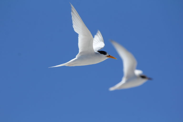
The region supports many species listed in migratory bird agreements with Japan (JAMBA), China (CAMBA) and the Republic of Korea (ROKAMBA) as well as threatened species, such as the Little Tern, Latham’s Snipe and Hooded Plover and a range of seabirds.
The majority of the coast in the West Gippsland region is on public land, with a limited amount in private ownership. The width and type of the public land varies greatly, with large national parks in some areas (such as Wilsons Promontory) and narrow foreshore reserves adjoining some towns.
The new Yallock-Bulluk Marine and Coastal Park combines 40kms of coastal reserves from San Remo to Inverloch, to better protect the natural and cultural heritage while improving access, facilities and recreation opportunities.
Wilsons Promontory Marine Park is Victoria’s largest and most southerly marine national park. It is home to one of the richest marine ecosystems in Australia. Its spectacular underwater world rivals that of the Great Barrier Reef2.
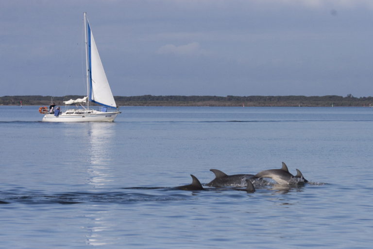
The Burrunan dolphin is endemic to southern Australian waters, and is listed as critically endangered under the Flora and Fauna Guarantee Act 1988. There are only two known resident populations, one in the Gippsland Lakes and on in Port Phillip. There are important migration paths for Blue, Southern Right and Humpback whales, and breeding colonies for Australian and New Zealand fur seals. Other significant marine habitats include seagrass meadows along parts of the Gippsland coast and the southernmost global extent of mangroves in Corner Inlet3.
Knowledge of the marine environment, and in particular threats to the marine environment from terrestrial land uses is a policy area that is still developing. Developments in this field will inform future strategic planning for marine and coastal environments under the next RCS.
Blue Carbon
Coastal saltmarsh, mangroves and seagrass have a key role in carbon sequestration. Rates of carbon accumulation in these ecosystems can be 30-50 times higher than rates in the soils of terrestrial forests. This is in part because blue carbon ecosystems can trap particles and suspend sediments out of the water column. Undisturbed, these sediments accrete over time. This allows blue carbon ecosystems to continually capture carbon, unlike terrestrial ecosystems in which carbon capture may eventually plateau4.
Condition and Trends
Water quality associated with the Gippsland Lakes Ramsar Site has been included under the Coast and Marine theme in accordance with the RCS Outcomes framework. At the time of preparation there was no current information for marine water quality for the Corner Inlet Ramsar Site.
Gippsland Lakes and catchment water quality
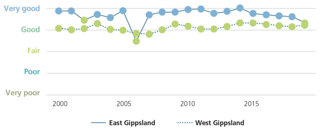
The EPA’s report card provides a snapshot of environmental water quality in the Gippsland Lakes and catchment. In 2019-20, water quality in the catchments of West Gippsland was rated as good and has remained relatively consistent over time.
Furthermore, water quality within the forested areas on the slopes of the Great Dividing Range was maintained at very good to good. Water quality declined along the mid and lower reaches of the main rivers where cleared land and urbanisation have impacted water quality5.
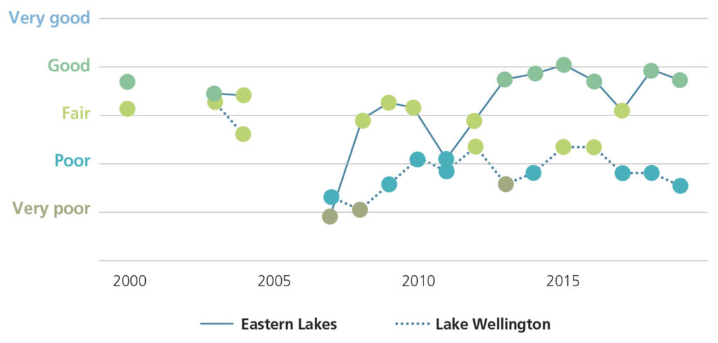
Historically, water quality in Lake Wellington has been rated as poor or very poor. Lake Wellington is a sink for sediments, nutrients and contaminants. Wind and waves within the shallow waters of the lake can re-suspend sediments and nutrients. Algal blooms often develop because of the high availability of nutrients. These processes are reflected in the ‘poor’ Water Quality Index score in 2019–20. Salinity was included in the 2019-20 assessment resulting in an improvement in scores compared with previous report cards, because salinity in Lake Wellington typically ranges between fair and good. In this case, a better score doesn’t necessarily mean that water quality itself has improved from last year.
Coastal vegetation
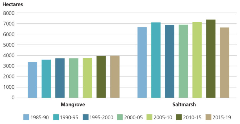
An assessment of landcover data indicates that there is 6,667 ha of saltmarsh vegetation, and 4,041 ha of mangroves across the West Gippsland region. At the regional scale, the area of mangroves has increased by around 17% over the last 35 years whilst saltmarsh has remained relatively stable6.
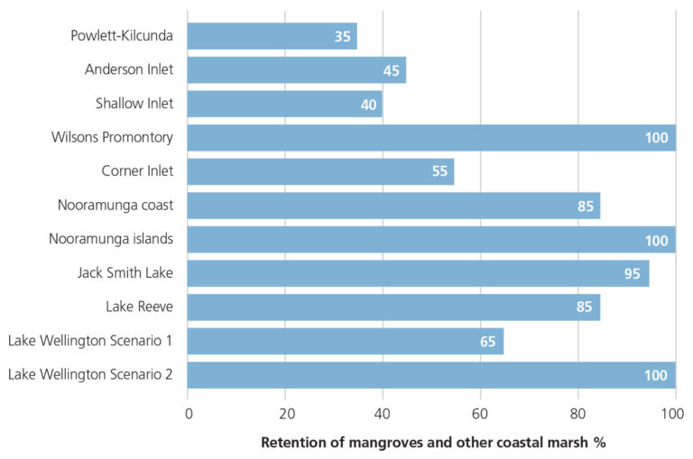
Whilst this is promising, there are sections of coastline that retain low levels of coastal saltmarsh compared with pre-European estimates, primarily due to conversion to pasture1. This includes Powlett Kilcunda, Shallow Inlet, Anderson Inlet and Corner Inlet.
Select Marine and Coastal condition indicators
A selection of other marine and coastal condition indicators and their trends were last reported as part of Victoria’s State of the Environment (SoE) 20187, as outlined to the right.
Further information on saltmarsh and mangrove extent based on land cover data and the most recent habitat mapping results are provided in the Corner Inlet and Nooramunga local area page.
| INDICATOR | STATUS | TREND | DATA QUALITY |
|---|---|---|---|
| Saltmarsh extent | Good | No data* | Poor |
| Seagrass condition at Corner Inlet and in the Gippsland Lakes | Fair | Stable to declining ** | Fair |
| Mangrove extent at Corner Inlet and the Nooramunga Marine & Coastal Park | Fair | No data* | Good |
| Migratory shorebirds at Corner Inlet | Fair | Declining | Fair |
| Marine and coastal birds at Gippsland Lakes | Fair | Trend depends on species | Good |
| Piscivorous (fish-eating) birds at Corner Inlet | Good | Improving | Good |
**See the Corner Inlet and Nooramunga local area page for the most recent habitat mapping results.
Shorebirds and waders
Shorebirds, also known as waders, are found in coastal environments including beaches, rocky shores, mudflats, intertidal wetlands and lagoons or on the fringes of freshwater wetlands.
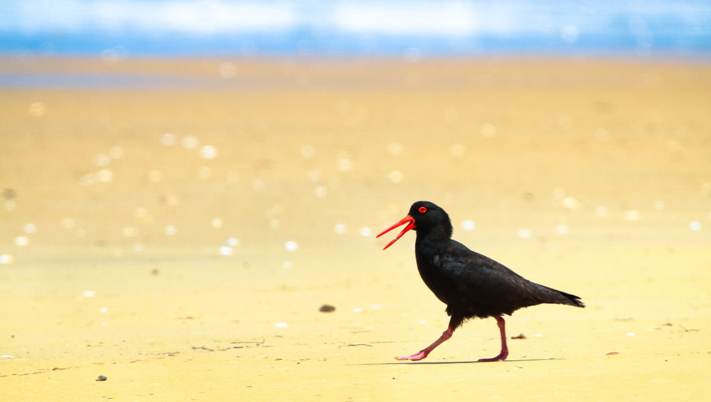
They include Snipes, Godwits, Knots, Stints, Sandpipers, Plovers, Terns and Oystercatchers.
In West Gippsland, the number of resident beach-nesting Hooded Plovers appears stable between San Remo in the west and Seaspray in the east, according to BirdLife Australia’s biennial counts of beach-nesting birds. However, they continue to experience poor breeding success due to human disturbance, off-leash dogs, predation by introduced and native species, and tidal inundation. Spread of coastal weeds such as Sea Wheat-grass and Sea Spurge has resulted in loss of suitable breeding habitat and the area continues to shrink due to sea level rise.
Anderson, Shallow and Corner Inlets are internationally important sites for migratory shorebirds.
Threats to migratory shorebirds at these three inlets include:
- Limited scientific knowledge about the birds
- Human disturbance
- Altered hydrological regimes
- Vegetation encroachment
- Pollution
- Lack of coordinated management.
Preserving key roosting, and feeding habitats, such as these three inlets is incredibly important, as migratory shorebird species continue to decline globally and face many threats along the Flyway including in Australia.
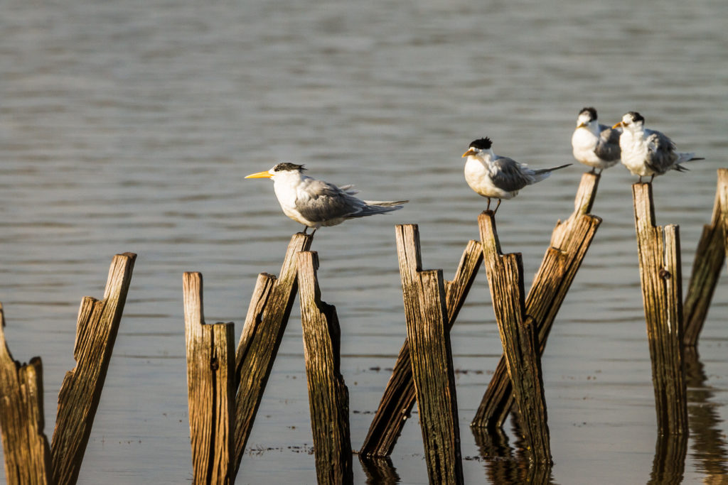
Crested Terns
Coastal and Marine Protected Areas in the West Gippsland Region
While most of the region’s 623km of coastline is protected by a thin strip of coastal reserve, there are significant marine reserves, and a large area of coastline protected within the Wilsons Promontory National Park8. The new Yallock Bulluk Marine and Coastal Park combines 40kms of coastal reserves from San Remo to Inverloch, to better protect the natural and cultural heritage of this stretch of Bunurong Country while improving access, facilities and recreation opportunities11.
| PROTECTED AREA | SIZE |
|---|---|
| Corner Inlet Marine and Coastal Park | 18,000 ha |
| Nooramunga Marine and Coastal Park | 15,000 ha |
| Wilsons Promontory Marine National Park | 15,555 ha |
| Shallow Inlet Marine and Coastal Park | 1,971 ha |
| Bunurong Marine National Park | 2,050 ha |
| Bunurong Marine Park | 1,259 ha |
| Ninety Mile Beach Marine National Park | 2,650 ha |
Index of Estuary Condition
A condition assessment method for estuaries has been developed by the Department of Environment, Land, Water and Planning. The Index of Estuary Condition (IEC) was tested, refined and applied over a decade to allow the first consistent and rigorous assessments of all estuaries across Victoria. The IEC assesses estuarine resource condition for the purposes of:
- Reporting on the condition of estuaries across Victoria
- Assisting the prioritisation of management investment among estuaries
- Providing a baseline for assessing long-term changes in resource condition.
The IEC consists of five themes: physical form, hydrology, water quality, flora and fauna.
The inaugural IEC report contains an assessment of 29 estuaries in the West Gippsland region9.
21% of estuaries were assessed as being in excellent condition, 24% of estuaries were in good condition, 24% in moderate condition and 31% in poor condition.
Estuaries in excellent condition included those within Wilsons Promontory National Park. Estuaries in good condition were mostly tributaries to Corner Inlet. Estuaries in poor overall condition included tributaries to Lake Wellington, estuaries along the western shoreline of Corner Inlet and intermittently open and closed estuaries of the Bass Coast. The estuaries in poor condition, with the exception of the Avon and Latrobe rivers, had the majority of their catchments dominated by agriculture.
Major Threats and Challenges
The key threats and challenges influencing coastal and marine environments include climate change and coastal processes, nutrient and sediment runoff, invasive species, and population pressures. These are outlined further below:
Climate change and coastal processes
The West Gippsland coastline is vulnerable to coastal inundation during significantly high tides,
often in conjunction with storm surges. The severity of impacts varies depending on factors
including geomorphology, estuary characteristics and population and infrastructure inundated. In addition, individual weather events can vary due to precedent conditions, direction and severity.
Coastal and marine areas will continue to be impacted by the effects of sea level rise and ocean warming caused by climate change. Sea levels are expected to rise by greater than 0.8 metres by 2100. The frequency and intensity of storm surges are also expected to increase in response to the changing climate. These changes are expected to affect low-lying towns in the region, as well as a vulnerable coastal and marine ecosystems and cultural values.
Coastal seas are also expected to be warmer and more acidic increasing pressure on already vulnerable coastal ecosystems.
Nutrient and sediment runoff from catchments
Agricultural, urban and forestry uses influence water quality by causing nutrient and sediment pollution, threatening estuaries and coastal ecosystems. For example, in Corner Inlet there are strong connections between catchment nutrients and sediments, algal blooms, reduced light penetration and seagrass decline, which in turn can impact the inlet’s fish and bird populations.
Marine pests and invasive species
Marine and coastal pests include non-native plants and animals that have been introduced into Victoria’s marine environment. In many cases their reproduction and spread have negative impacts on ecosystems and their amenity. Invasive species in and around West Gippsland’s coastal waters include Japanese Kelp detected at Port Welshpool, and Pacific Oyster, the European Green Shore Crab, and the Asian Date Mussel detected in the Gippsland Lakes. Spartina (Spartina anglica and Spartina x townsendii sp.) is also of major concern in the coastal habitats of Corner Inlet and has been the subject of a targeted control program and a Spartina Management Plan.
Overabundant native marine species can also impact on coastal marine ecosystems. For example, Ravens and Magpies are predators of beach nesting bird eggs and the native Purple Sea Urchin has become overabundant in parts of the Corner Inlet Ramsar Site, feeding on seagrass and creating bare areas10.
Population pressures and urbanisation
Population growth and subsequent development and the resulting pressure to support increased tourism and recreation, is a key threat to the health of the region’s coastal environments.
Growing numbers of domestic and international visitors will place further stress on marine and coastal environments, building pressure to increase access with new roads, car parks and other visitor management and attractions infrastructure.
Continuing demand for urban expansion along the coast, places pressure on coastal habitats that are not protected within formal parks and reserves.
The management and development of coastal land is also recognised as a key influence on the condition of the coast. These impacts include increased stormwater runoff from increased area of impervious surfaces, erosion, litter, nutrient and sediment pollution, and disturbance of nesting wildlife1.
The major drivers of change for the Coast and Marine theme were identified through consultation with partner organisations as outlined below8.
Major drivers of change Coast and Marine
| CLIMATE CHANGE | POPULATION AND DEMOGRAPHICS TRENDS | LAND-USE CHANGE | INDUSTRY OUTLOOK |
|---|---|---|---|
| ▪ Increase in frequency and extent of coastal inundation, erosion and flooding as a result of sea level rise, storm surge, tides and rainfall ▪ Impact on coastal habitats, agriculture and peri urban areas through inundation and salinisation ▪ Synergistic effects of ocean warming and acidification on coastal and marine ecosystems and biota | ▪ Population increase are outstripping predictions in coastal areas ▪ Additional pressure for infrastructure development in coastal areas to create more attractive tourism destinations ▪ Smaller lot subdivisions are occurring along the coast in the Bass Coast and South Gippsland Shire Council areas | ▪ Continuing urban expansion in coastal areas, and the associated impacts on stormwater, erosion, sediment and nutrient pollution ▪ A decrease in agricultural production in the coastal zone due to land competition | ▪ Increasing tourism ▪ New and emerging industries within the coastal and marine environment, such as wind farms, oil and gas exploration |
Opportunities and Management Directions
Priority management directions have been identified for the Coast and Marine theme through a review of RCS3 and consultation with Traditional Owners, the community and partner organisations.
Established management directions will be delivered through existing sub-strategies and action plans.
Opportunities will be further developed or pursued through RCS implementation to help support Integrated Catchment Management in the region.
Priority opportunities and management directions for the Coast and Marine theme
| MANAGEMENT DIRECTION | DETAILS | ESTABLISHED MANAGEMENT DIRECTION | OPPORTUNITY | PARTNERS |
|---|---|---|---|---|
| Implement the West Gippsland Waterway Strategy 2014-2022, renewing this strategy by 2023 | Priorities include: actions associated with water quality, water for the environment, estuaries and coastal wetlands | ✔ | WGCMA, Traditional Owners, Water Authorities, Local Government, Landcare, VEWH | |
| Finalise the creation and planning for the Yallock-Bulluk Marine and Coastal Park | ✔ | Parks Victoria, BLCAC, DELWP | ||
| Support coastal crown land managers to prepare and implement Coastal and Marine Management Plans | Including managing competing uses, protecting cultural values, taking an ecosystem based approach and addressing climate change | ✔ | DELWP, Local Government, Committees of Management, Traditional Owners | |
| Deliver priority Regional and Strategic Partnership initiatives from the Marine and Coastal Strategy | Initial priority is the Cape to Cape project (Inverloch) | ✔ | DELWP, Local Government, Traditional Owners, Parks Victoria, WGCMA | |
| Support regional implementation of the Marine & Coastal Strategy | ✔ | DELWP, Local Government, Traditional Owners, Parks Victoria, Committees of Management, WGCMA | ||
| Participate in a statewide process to determine arrangements for the provision of coastal erosion advice | ✔ | DELWP, WGCMA | ||
| Manage the impacts to sensitive coastal environments from the pressures of increased visitation | Options include: communications, improved infrastructure, restricting access informed by management planning | ✔ | DELWP, Parks Victoria, Local Government, Committees of Management, Traditional Owners | |
| Support coastal land managers, agencies and private land managers to adapt or make a planned retreat in areas impacted by sea-level rise, storm surge and coastal processes | In accordance with the approved pathways under the Marine and Coastal Policy 2020 including, infrastructure planning and relocation, erosion control and providing ecosystems ‘room to move’ | ✔ | ✔ | DELWP, WGCMA, Local Government, Parks Victoria |
| Consider and plan for the combined impacts of climate change and changing land use on estuaries and coastal wetlands | Includes investigation of options for permanent protection | ✔ | DELWP, WGCMA, Local Government, Parks Victoria, Traditional Owners | |
| Continue to progress options to address the management and impacts of seawalls, including maintenance requirements | ✔ | Local Government, WGCMA, DELWP | ||
| Implement Conservation Action Plans for the Gippsland Plains and Strzelecki Ranges and Wilsons Promontory Landscapes | Addressing priority threats to conservation assets in the Parks Victoria managed estate | ✔ | Parks Victoria, Traditional Owners, WGCMA, DELWP | |
| Implement the Gunaikurnai Victorian Government Joint Management Plan | Addressing conservation and cultural assets in the Lakes NP & Gippsland Lakes CP | ✔ | GKTOLM, Parks Victoria, DELWP | |
| Implement the Gippsland Lakes and Corner Inlet Ramsar Sites Management Plans | Addressing priority threats to critical Components, Processes and Services | ✔ | WGCMA, EGCMA, GLaWAC, DELWP, Parks Victoria | |
| Continue to deliver existing ICM, deliver integrated catchment management initiatives in priority catchments | Perry River and Providence Ponds, Powlett River catchments (priorities in 2021) | ✔ | WGCMA, Traditional Owners, Community representatives, Landcare, DELWP, DJPR, Local Government, Parks Victoria, TfN, Water Authorities | |
| Work with the community in priority areas to prepare whole of landscape integrated catchment management plans | Initial priorities include the Tarwin catchment and the Strzeleckis | ✔ | As above |
Regional Outcomes
This section sets out the long term (20-year) and medium term (6-year) outcomes for the region’s coast and marine environments. The regional outcomes include those aligned with the statewide outcomes framework as well as regionally specific outcomes developed in collaboration with RCS partners.
The RCS outcomes hierarchy can be found here with a more detailed matrix showing how the medium term outcomes align to local areas here.
Long term outcomes – by 2041 we will:
Aligned to the statewide outcomes framework
- Reduce the amount of nutrients and sediments entering coastal and marine environments from the catchment
- Maintain the overall extent of coastal vegetation communities at 2015-19 levels.
Regionally specific outcomes
- Maintain the ecological character of Corner Inlet and the Gippsland Lakes.
Medium term outcomes – by 2027:
Aligned to the statewide outcomes framework
- Environmental reference standards for sediment and nutrient load reduction to Ramsar sites are met.
Regionally specific outcomes
- Increase the area of coastal saltmarsh that is protected or managed.*
Footnotes
*This outcome will be quantified in the renewal of the West Gippsland Waterway Strategy.
References
- VCMC. Catchment Condition and Management Report 2017. East Melbourne, Victoria: Victorian Catchment Management Council, 2017
- Parks Victoria. Wilsons Promontory Marine National Park. Parks Victoria. [Online] n.d. [Cited: 30 April 2021]
- GCB and DELWP. Gippsland Regional Coastal Plan 2015-2020. East Gippsland: Gippsland Coastal Board and the Department of Environment, Land, Water and Planning, 2015
- VEAC. Assessment of Victoria’s Coastal Reserves. East Melbourne: Victorian Environmental Assessment Council, 2020
- EPA. Report card 2019-20. Publication 1923. Melbourne: Environment Protection Authority, Victoria, 2020
- DELWP. Victorian Land Cover Time Series Data 1985 – 2019. [Spatial data] East Melbourne: Department of Environment, Land, Water and Planning, 2020
- CES. Interim Victorian State of the Environment Report 2018. Melbourne, Victoria: Commissioner for Environmental Sustainability Victoria, 2018
- RMCG. West Gippsland RCS Review and Renewal. Final Report. Torquay: RM Consulting Group for the West Gippsland Catchment Management Authority, 2020
- DELWP. DELWP (2021). Assessment of Victoria’s estuaries using the Index of Estuary Condition: Results 2021. Department of Environment, Land, Water and Planning, East Melbourne, 2021
- Parks Victoria. Conservation Action Plan: Gippsland Plains and Strzelecki Ranges Parks Landscape. Parks and Reserves Managed by Parks Victoria. Parks Victoria, 2021
- Parks Victoria. Yallock Bulluk Marine and Coastal Park. [online] n.d [Cited: 2 July 2021].

